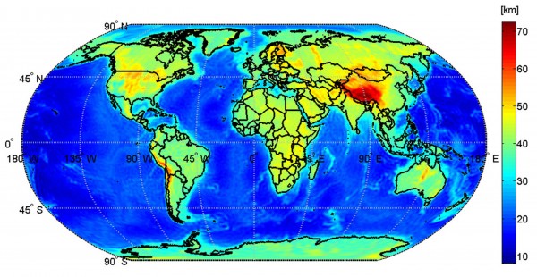
This map shows the global Mohorovičić discontinuity – known as Moho – based on data from the European Space Agency's GOCE satellite. (Image: ESA/GEMMA project)
The European Space Agency (ESA) has produced the first global high-resolution map of the boundary area between the Earth’s crust and mantle, which could offer new clues into the dynamics of Earth’s interior.
The new map, of what’s called the Mohorovičić discontinuity (Moho), was created with data provided by the GOCE satellite.
The Moho boundary was named after Andrija Mohorovičić, a Croatian scientist who discovered it back in 1909.
Although this region has never been seen, scientists can spot it through seismic measurements when there are sharp and sudden changes in the speed of earthquake waves, compared to measurements taken within the crust. Scientists presume that this may be due to a change in rock types.
Earth’s crust is the outermost shell of the planet. The crust is important because we live on it and it’s where all our geological resources – such as natural gas, oil and minerals – come from.
The crust and upper mantle layers of the Earth are where major geological processes, like earthquakes and volcanism, take place.
In order to study and understand the Moho, scientists currently use data models based on either seismic or gravity measurements, but those methods can provide limited information.
According to ESA, the new maps make it possible to estimate the Moho depth worldwide, including areas where ground data is not currently available.


Comments are closed.