

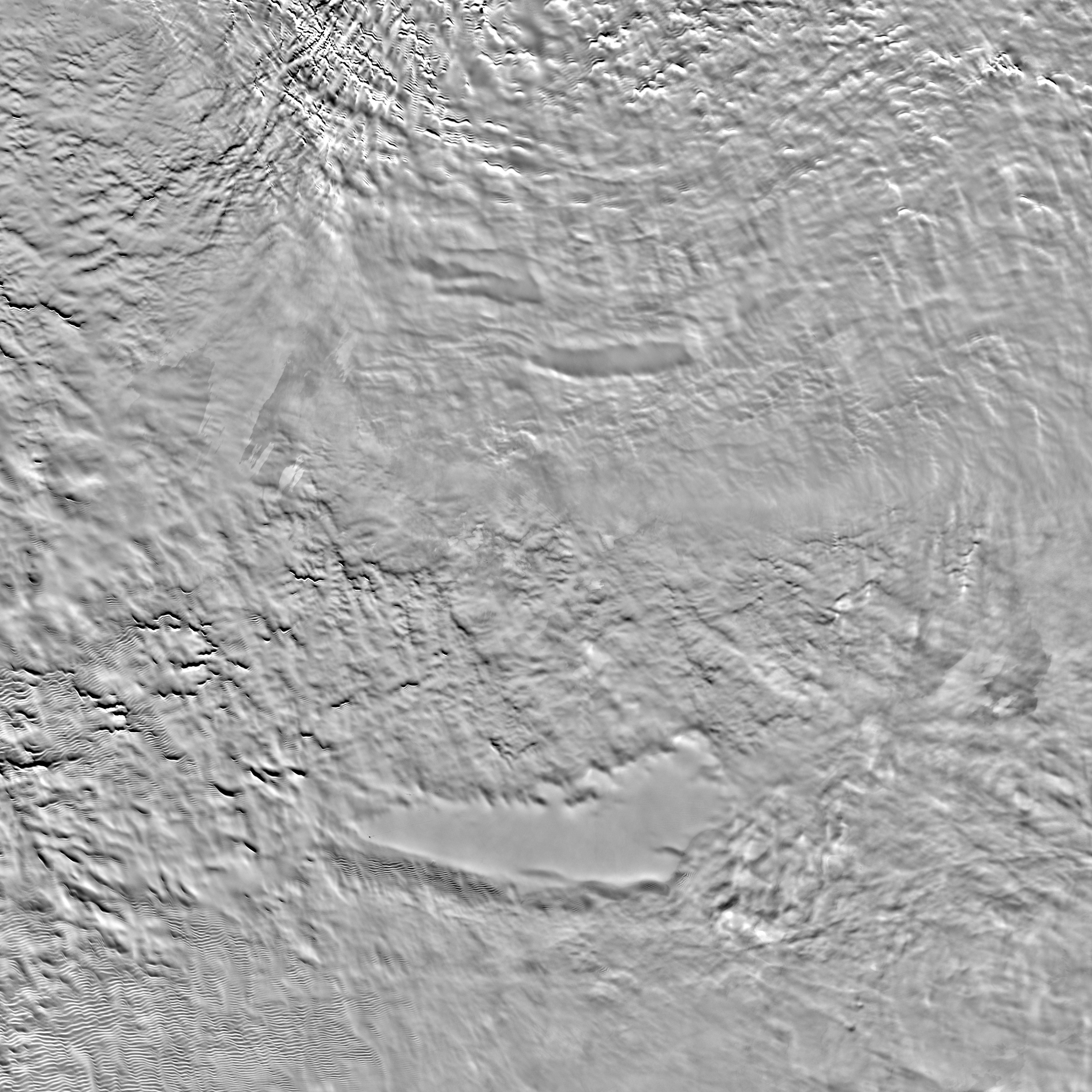
This image shows the location of record low temperature measurements for Antarctica. (Ted Scambos, National Snow and Ice Data Center)
Winter officially arrives in the Northern Hemisphere in about 10 days (12/21/13). Here in the Washington, DC area, temperatures have already been dropping below 0° C at times.
While some of us are already complaining about the recent icy temperatures we know it could be a lot worse!
Scientists from NASA and the U.S. Geological Survey (USGS), using a variety of sophisticated devices, such as those on the Landsat 8 satellite launched earlier this year (see related story), have found the coldest place on Earth.
Temperatures at spots along a 1,000 km strip of a remote and desolate ice plateau in East Antarctica have been measured between −92° to −93.2° C.
Project researchers made the temperature measurements between 2003 and 2013.
They used the Moderate Resolution Imaging Spectroradiometer (MODIS) sensor, an instrument installed on NASA’s Terra and Aqua satellites as well as the Advanced Very High Resolution Radiometer (AVHRR) which is aboard several National Oceanic and Atmospheric Administration satellites.
NASA Video – The Coldest Place in the World (NASA)
During the 2013 Southern Hemisphere winter (6/21/13 – 9/23/13) their temperature measurements were augmented with data that was taken by equipment aboard the new Landsat 8 Earth observing satellite.
The newly recorded coldest temperature of -93.2° C was set on August 10, 2010 and it beats a record from more than 30 years ago when it was −89.2° C on July 21, 1983 at the Vostok Research Station in East Antarctica.
Ted Scambos the lead scientist at the National Snow and Ice Data Center (NSIDC) at the University of Colorado Boulder also joined the NASA/USGS team for this project. “I’ve never been in conditions that cold and I hope I never am,” said Scambos. “I am told that every breath is painful and you have to be extremely careful not to freeze part of your throat or lungs when inhaling.”

An Atlas-V rocket with the Landsat Data Continuity Mission (LDCM) spacecraft onboard is seen as it launches on Monday, Feb. 11, 2013 at Vandenberg Air Force Base, Calif. (Photo: NASA/Bill Ingalls)
These record temperatures in East Antarctica are much colder than a few other areas where sub-freezing temperatures are normal.
The project scientists found that the lowest recorded temperature in the United States was in Alaska coming in at −62° C. In northern Asia cold temperatures have dipped to -68° C, while a temperature of -75° C was measured at the peak of the Greenland Ice Sheet.
According to NASA the coldest permanently inhabited place on Earth is located in northeastern Siberia, where temperatures dropped to -67.8° in the towns of Verkhoyansk – 1802 and Oymyakon – 1933.
The new record cold temperatures were found by the scientists in several 5 by 10 km pockets where the topography of the area shapes shallow hollows of about 2 to 4 meters deep.
These small dips in Antarctic landscape are close to an ice ridge that runs between the ice-dome peaks of Dome A (Argus) and Dome F (Fuji) which are located on the East Antarctic Ice Sheet. An ice-dome has been described as a mass of ice located on an ice-sheet that has been shaped into a dome.
The researchers say that the cold air begins near the snow surface. Since cold air is thought to be much denser that the air above, this already cold air then moves down into those hollows making the air even colder, under ideal conditions.
“The record-breaking conditions seem to happen when a wind pattern or an atmospheric pressure gradient tries to move the air back uphill, pushing against the air that was sliding down,” Scambos said. “This allows the air in the low hollows to remain there longer and cool even further under the clear, extremely dry sky conditions. When the cold air lingers in these pockets it reaches ultra-low temperatures,” he added.
The researchers happened to notice the record low temperatures while they were studying some unusual cracks on East Antarctica’s ice surface that could be several hundred years old.
Satellite image shows a portion of the East Antarctic Ice Sheet (NASA)
The scientists say that they suspect that a layer in the atmosphere above the ice plateau reaches a certain minimum temperature and is preventing the ice plateau’s surface from getting any colder.
“There seems to be a physical limit to how cold it can get in this high plateau area and how much heat can escape,” Scambos said. “The levels of carbon dioxide, nitrogen oxide, traces of water vapor and other gases in the air may impose a more or less uniform limit on how much heat can radiate from the surface.”
The researchers say that they will continue to refine their map of Earth’s coldest places using Landsat 8 data.
“It’s a remarkable satellite and we’ve repeatedly been impressed with how well it works, not just for mapping temperature but for mapping crops and forests and glaciers all over the world,” Scambos said.


A little jab: an article from Voice of America shows miles in km and temperature in centigrade! The horror…
These are Scientists, thats why.
I live in Utah and lately it has been seeing a lot of cold temperatures. Cold for us is 0 F. It is always comforting to know that Utah is not so bad.