

The Antarctic Peninsula (Vincent van Zeijst via Wikimedia Commons)
An altered Antarctic landscape is one of the rarely discussed side effects of accelerated ice melting.
For years as the ice grew in Antarctica, its weight compressed the ground beneath it. But when the ice melted and this weight was reduced, the ground sprang back, rebounding over time.
However, the ground in the Northern Antarctic Peninsula is rebounding at a faster rate than the elastic response of the lighter weight load should allow.
An international team of researchers, led by scientists at the UK’s Newcastle University, found that over the past year, the land in that area of the Antarctic has risen 15 millimeters.
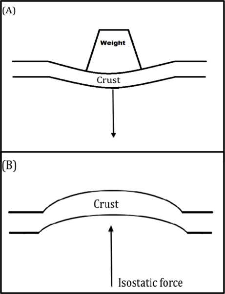
A simple drawing illustrating the elastic response of the ground following the removal of large amount of weight generated by objects such as a glacial ice sheet. (Amorse3522 via Wikimedia Commons)
Models created for the study have predicted that this rate could get as high as 45 millimeters per year, according to Peter Clarke of Newcastle University, one of the authors of the study.
The land rise in nearby areas was less than a millimeter each year.
Now Clarke and his colleagues think they know what might be causing the rapid ground rise.
As explained in the journal Earth and Planetary Science Letters, the research team found that the Earth’s mantle, hundreds of kilometers beneath the surface, is flowing about 1,000 times faster than was thought possible, which in turn is allowing the land above to move upward at a faster rate.
The researchers think that the increased flow of the mantle may be due to some chemical or temperature changes brought on by the ice melt.
To reach their findings, Clarke and the team brought together a wide variety of different data sets from scientific GPS receivers, which are much more precise than those people use in their cars. The GPS devices measured movements of the solid Earth within millimeters or less than millimeters per year.
In studying the GPS data for the North Antarctic Peninsula, the researchers noticed that the Earth was uplifting at a rate faster than they thought was possible.
After making this finding, the research team studied data gathered by NASA’s ICESat – Ice, Cloud, and land Elevation Satellite, which has a laser pointing downward from the satellite that measured the height of the ice sheet in the region.

In early 2002, the Larsen B Ice Shelf, in the northern Antarctic Peninsula, collapsed in just over one month. This image taken by NASA on Feb. 17, 2002, shows fragments of the ice shelf floating in the Weddell Sea. (NASA)
Those measurements showed that the ice sheets, since the collapse of the Larsen-B Ice Shelf in 2002, were losing their ice in a few places at a rate of tens of meters per year.
To reach their conclusions, the researchers took the results from both the GPS and ICESat data studies and combined them into a mathematical model that showed how the Earth should respond to the change in the weight of the ice.
“The significant thing is that this part of the Antarctic Peninsula is behaving so differently to what we think is true for the rest of the Antarctic and indeed the rest of the world,” said Clarke. “And this is going to have an implication for the way in which we can use measurements of the ice height and the gravity field of the Earth in order to monitor the changes in the ice sheet in the future.”


What the world really needs is a clean limitless source of energy. Unlike the other aneutronic fusion projects that are privately held companies LPP is crowfunding their breakthrough: https://www.indiegogo.com/projects/focus-fusion-empowertheworld–3
Forget fusion. Here is the completely clean solution that desalinates water in the process to boot. http://www.cnn.com/2014/04/28/tech/innovation/the-artificial-leaf-power-solar-electricity/